Starting this week I will be including posts on our blog in a pseudo-cruising guide format, outlining the places we have been on our trip. These are meant more as a reference for our boating friends that may be heading north in the near future, but I will also try to include photos and personal experiences so there may be interesting information for non-boaters as well.
Also, I encourage anyone reading our blog to use the comments section at the end of each post, or to send us email if you have comments about any of the posts. It's nice to have electronic mail in any form waiting for us when we arrive somewhere with internet access.
Monday, June 20, 2011
Saturday, June 18, 2011
Sailing
One of the hardest things for a sailor/photographer is to get pictures of your own boat under sail. We always seem to be a little too busy trying to avert disaster to snap a quick photo, and even when we remember to do so the pictures leave something to be desired when they are shot from the deck of the boat. Some days you get lucky, have a beautiful day of sailing, have another boat sailing alongside so you can take pictures of each others boats, and share an anchorage that night so you can easily swap photos. The included photo can also be found on the photographers blog here: Estrellita


Wednesday, June 15, 2011
Leaving Canada
Our blog has been pretty quiet lately, we've been keeping away from civilization, and unfortunately that means no internet connection. In a couple of days we will be in Alaska, and I should have a chance to post a bunch of backdated entries and get everyone caught up. The internet connection I'm currently using is a couple miles away and the freighter that is anchored between us and shore keeps swinging at anchor and blocking the connection, so I'll wait to post more and send this while I can.
Friday, June 10, 2011
Bishop Bay, B.C Mainland, Ursula Channel


Thursday, June 9, 2011
Work Bay, Sarah Island, Finlayson Channel
Situated at the north end of Finlayson Channel, Work Bay is a good anchorage to use when preparing for the long run up Graham Reach and Fraser Reach. It is also less than 10 miles from Hiekish Narrows to make planning for the currents easier. The bay is somewhat open to the south and the wind and swell could reach inside during moderate southerly weather, but there is good protection from all other directions. Anchoring depths at the head of the bay are good at 10-15 meters and there is swinging room for several boats. It looks like depth would be reasonable to anchor in the eastern arm, but this location would be even more exposed than at the head of the bay. The approach is clear and easy and could be done by radar or in reduced visibility.
We tried prawning in the outer bay with no success, the depths are 150-200 meters within a boat length of shore until you get near the entrance to the inner bay so finding a convenient ledge to set traps is challenging. We did not try crabbing but had very good success in Bottleneck Inlet which is only a few miles south.
We tried prawning in the outer bay with no success, the depths are 150-200 meters within a boat length of shore until you get near the entrance to the inner bay so finding a convenient ledge to set traps is challenging. We did not try crabbing but had very good success in Bottleneck Inlet which is only a few miles south.
Wednesday, June 8, 2011
Rescue Bay, Susan Island, Mathieson Channel
Rescue Bay is the only good all-weather anchorage for boats wanting to pass through Fjordlands but not spend extra days there. There is a drying rock in the southeastern part of the bay, and a shallow spot slightly north and on the opposite side of the bay, but otherwise depths are good for anchoring in much of the bay and there is room for quite a few boats. We anchored in the southwest corner in about 13 meters with good depths within a few boat-lengths of shore. It is worth the extra time to position your boat in the anchorage to enjoy the views north through the islands, the snow covered peaks are stunning.
Tuesday, June 7, 2011
Wigham Cove, Yeo Island, North of Seaforth Channel
Wigham Cove is located about 8 miles north of the Bella Bella/Shearwater area, making it a convenient stop for boats headed north that want to stop in either town for supplies but don't want to spend the night at the docks. The entrance to the cove is narrow with quite a few rocks that dry at low tide, but the depths in the channel are good if you favor the west side. Anchorage is available in either the east end or the south end of the bay. The east end is deep, about 20 meters or more through most of the area, but the approach is clear once past the rocks in the entrance. We anchored in the south end, which requires passing between the small island and a rocky point on the eastern shore, but once past this shallow point it opens up and depths are good with swing room for several boats. We anchored in about 12 meters in the center of the arm. Avoid the large rock at the southern-most point of the south arm.
Saturday, June 4, 2011
Beales Bay, Cunningham Island, Gunboat Passage
Because it is only about 5 miles from the town of Shearwater, Beales Bay is often overlooked. There is a large drying ledge near the entrance to the lagoons that restricts swing room for anything more than a couple boats. The bay is open to the south, but even with winds blowing from the west down Gunboat Passage there is minimal wave action in the bay. Anchoring depths are good at about 10 meters at the head of the bay. There are two lagoons to explore off the west side of the bay, the first is small but is accessible at all tide levels. It looked like this passage could be passable for cruising boats at high tide, but we didn't check the depths inside the first narrows. The second narrows is shallow and has a drop of several feet at low tide but can be accessed by dinghy at the higher end of the tides. There are islands and several arms of this second lagoon that can be explored by dinghy.
We spent several days here waiting out gale forecasts, seeing very little wind or weather within the bay. We had good luck crabbing in several locations within the bay.
We spent several days here waiting out gale forecasts, seeing very little wind or weather within the bay. We had good luck crabbing in several locations within the bay.
Friday, June 3, 2011
Sea Otter Inlet, Hunter Island, Fitz Hugh Sound
Sea Otter Inlet is broken up into three arms, the north arm is also known as Crab Cove. We have only anchored in the south arm, but all three offer reasonable protection for anchoring. The south arm is long and narrow, with two breaks in the wooded shores near the head. One passage dries on most tides and looks out into Fitz Hugh Sound, the other is a shallow rock-filled passage that connects to Target Bay in Nalau Passage. Anchoring depths are good at around 8 meters at the head with room for other boats staggered down the length of the arm in progressively deeper water.
Crabbing was poor in the arm, but we caught quite a few rockfish around the south point of the entrance and around Hanna Islet.
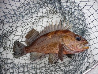
Crabbing was poor in the arm, but we caught quite a few rockfish around the south point of the entrance and around Hanna Islet.

Subscribe to:
Posts (Atom)